|
| at: |
Talladega National Forest |
Data from USFS GIS
 show on map
 animate
Trail users:


Elevation Profile
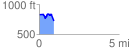
 0.921203 mi
 95.47 ft
 209.88 ft
 -114.41 ft
 4.31 %
GPX Downloads: Track Route
![]()
|
| at: |
Talladega National Forest |
show on map
animate
0.921203 mi
95.47 ft
209.88 ft
-114.41 ft
4.31 %