|
| at: |
Talladega National Forest |
Data from USFS GIS
 show on map
 animate
Trail users:


Elevation Profile
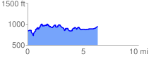
 6.418685 mi
 881.69 ft
 801.65 ft
 80.04 ft
 2.60 %
GPX Downloads: Track Route
![]()
|
| at: |
Talladega National Forest |
show on map
animate
6.418685 mi
881.69 ft
801.65 ft
80.04 ft
2.60 %