| at: |
Middle Prong/Shining Rock Wilderness |
Data from David Muse
 show on map
 animate
Trail users:

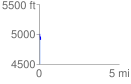
Elevation Profile
 0.082395 mi
 4.36 ft
 100.01 ft
 -95.65 ft
 22.99 %
GPX Downloads: Track Route
![]()
| at: |
Middle Prong/Shining Rock Wilderness |
show on map
animate
0.082395 mi
4.36 ft
100.01 ft
-95.65 ft
22.99 %