| at: |
Middle Prong/Shining Rock Wilderness |
Data from David Muse
 show on map
 animate
Trail users:

Elevation Profile
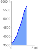
 3.263105 mi
 2334.76 ft
 250.89 ft
 2083.87 ft
 13.55 %
GPX Downloads: Track Route
![]()
| at: |
Middle Prong/Shining Rock Wilderness |
show on map
animate
3.263105 mi
2334.76 ft
250.89 ft
2083.87 ft
13.55 %