| at: |
Bonita Lakes |
Data from David Muse
 show on map
 animate
Trail users:

Elevation Profile
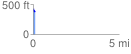
 0.101864 mi
 0.00 ft
 54.66 ft
 -54.66 ft
 10.16 %
GPX Downloads: Track Route
![]()
| at: |
Bonita Lakes |
show on map
animate
0.101864 mi
0.00 ft
54.66 ft
-54.66 ft
10.16 %