| at: |
Bonita Lakes |
Data from David Muse
 show on map
 animate
Trail users:


Elevation Profile
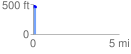
 0.197890 mi
 57.20 ft
 50.23 ft
 6.96 ft
 5.47 %
GPX Downloads: Track Route
![]()
| at: |
Bonita Lakes |
show on map
animate
0.197890 mi
57.20 ft
50.23 ft
6.96 ft
5.47 %