| at: |
Halpata Tastanaki Preserve |
Data from Karlos Bernart
 show on map
 animate
Trail users:


Elevation Profile
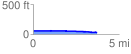
 3.716362 mi
 21.61 ft
 51.63 ft
 -30.03 ft
 0.26 %
GPX Downloads: Track Route
![]()
| at: |
Halpata Tastanaki Preserve |
show on map
animate
3.716362 mi
21.61 ft
51.63 ft
-30.03 ft
0.26 %