| at: |
Potts Preserve |
Data from Karlos Bernart
 show on map
 animate
Trail users:


Elevation Profile
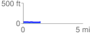
 1.492088 mi
 10.00 ft
 13.32 ft
 -3.33 ft
 0.17 %
GPX Downloads: Track Route
![]()
| at: |
Potts Preserve |
show on map
animate
1.492088 mi
10.00 ft
13.32 ft
-3.33 ft
0.17 %