| at: |
Santos |
Data from David Muse
 show on map
 animate
Trail users:


Elevation Profile
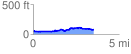
 3.517203 mi
 231.01 ft
 204.76 ft
 26.25 ft
 1.24 %
GPX Downloads: Track Route
Trailheads:
 Ross Prairie
![]()
| at: |
Santos |
show on map
animate
3.517203 mi
231.01 ft
204.76 ft
26.25 ft
1.24 %
Ross Prairie