| at: |
Wekiwa Springs State Park |
Data from Karlos Bernart
 show on map
 animate
Trail users:


Elevation Profile
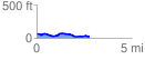
 2.770402 mi
 94.72 ft
 126.03 ft
 -31.31 ft
 0.86 %
GPX Downloads: Track Route
![]()
| at: |
Wekiwa Springs State Park |
show on map
animate
2.770402 mi
94.72 ft
126.03 ft
-31.31 ft
0.86 %