| at: |
Jimmie Davis State Park |
Data from David Muse
 show on map
 animate
I assume that this is a hiking trail because the sign where the Boggy Creek trail crosses the road only has a picture of a hiker on it. The trails are otherwise unsigned though and I have seen lots of kids ride their bikes on Boggy Creek, so perhaps it is open to bikes.
Trail users:
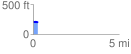
Elevation Profile
 0.291504 mi
 24.99 ft
 32.52 ft
 -7.54 ft
 2.11 %
GPX Downloads: Track Route