| at: |
Dawson Forest |
Data from Positive Flow
 show on map
 animate
Trail users:

Elevation Profile
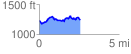
 2.568578 mi
 396.98 ft
 379.97 ft
 17.01 ft
 2.93 %
GPX Downloads: Track Route
![]()
| at: |
Dawson Forest |
show on map
animate
2.568578 mi
396.98 ft
379.97 ft
17.01 ft
2.93 %