| at: |
Dawson Forest |
Data from Positive Flow
 show on map
 animate
Trail users:


Elevation Profile
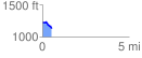
 0.539372 mi
 19.47 ft
 130.67 ft
 -111.20 ft
 4.59 %
GPX Downloads: Track Route
![]()
| at: |
Dawson Forest |
show on map
animate
0.539372 mi
19.47 ft
130.67 ft
-111.20 ft
4.59 %