| at: |
Dawson Forest |
Data from Positive Flow
 show on map
 animate
Trail users:


Elevation Profile
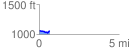
 0.674038 mi
 42.18 ft
 58.84 ft
 -16.66 ft
 1.65 %
GPX Downloads: Track Route
![]()
| at: |
Dawson Forest |
show on map
animate
0.674038 mi
42.18 ft
58.84 ft
-16.66 ft
1.65 %