| at: |
Leita Thompson Memorial Park |
Data from David Muse
 show on map
 animate
Trail users:

Elevation Profile
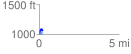
 0.217945 mi
 87.99 ft
 40.06 ft
 47.93 ft
 7.65 %
GPX Downloads: Track Route
![]()
| at: |
Leita Thompson Memorial Park |
show on map
animate
0.217945 mi
87.99 ft
40.06 ft
47.93 ft
7.65 %