| at: |
Richloam/Green Swamp WMA |
Data from Karlos Bernart
 show on map
 animate
Trail users:


Elevation Profile
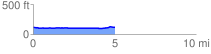
 5.006730 mi
 59.31 ft
 52.77 ft
 6.54 ft
 0.22 %
GPX Downloads: Track Route
![]()
| at: |
Richloam/Green Swamp WMA |
show on map
animate
5.006730 mi
59.31 ft
52.77 ft
6.54 ft
0.22 %