| at: |
Richloam/Green Swamp WMA |
Data from Karlos Bernart
 show on map
 animate
Trail users:


Elevation Profile
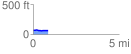
 0.887837 mi
 18.72 ft
 24.39 ft
 -5.68 ft
 0.52 %
GPX Downloads: Track Route
![]()
| at: |
Richloam/Green Swamp WMA |
show on map
animate
0.887837 mi
18.72 ft
24.39 ft
-5.68 ft
0.52 %