| at: |
Richloam/Green Swamp WMA |
Data from Karlos Bernart
 show on map
 animate
Trail users:


Elevation Profile
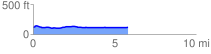
 5.894581 mi
 108.61 ft
 95.75 ft
 12.86 ft
 0.35 %
GPX Downloads: Track Route
![]()
| at: |
Richloam/Green Swamp WMA |
show on map
animate
5.894581 mi
108.61 ft
95.75 ft
12.86 ft
0.35 %