|
| at: |
Ocala National Forest |
Data from Karlos Bernart
 show on map
 animate
Trail users:


Elevation Profile
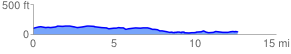
 12.644302 mi
 239.06 ft
 277.88 ft
 -38.82 ft
 0.42 %
GPX Downloads: Track Route
![]()
|
| at: |
Ocala National Forest |
show on map
animate
12.644302 mi
239.06 ft
277.88 ft
-38.82 ft
0.42 %