| at: |
Ocala National Forest |
Data from Karlos Bernart
 show on map
 animate
Trail users:


Elevation Profile
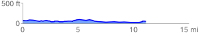
 11.132138 mi
 183.81 ft
 215.43 ft
 -31.62 ft
 0.37 %
GPX Downloads: Track Route
![]()
| at: |
Ocala National Forest |
show on map
animate
11.132138 mi
183.81 ft
215.43 ft
-31.62 ft
0.37 %