| at: |
Ocala National Forest |
Data from Karlos Bernart
 show on map
 animate
Trail users:


Elevation Profile
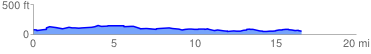
 16.760378 mi
 435.19 ft
 457.39 ft
 -22.20 ft
 0.52 %
GPX Downloads: Track Route
![]()
| at: |
Ocala National Forest |
show on map
animate
16.760378 mi
435.19 ft
457.39 ft
-22.20 ft
0.52 %