| at: |
Ocala National Forest |
Data from Karlos Bernart
 show on map
 animate
Trail users:


Elevation Profile
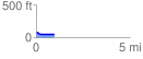
 0.974395 mi
 11.88 ft
 33.62 ft
 -21.74 ft
 0.65 %
GPX Downloads: Track Route
![]()
| at: |
Ocala National Forest |
show on map
animate
0.974395 mi
11.88 ft
33.62 ft
-21.74 ft
0.65 %