| at: |
Ocala National Forest |
Data from Karlos Bernart
 show on map
 animate
Trail users:


Elevation Profile
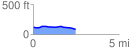
 2.475049 mi
 42.61 ft
 71.51 ft
 -28.90 ft
 0.55 %
GPX Downloads: Track Route
![]()
| at: |
Ocala National Forest |
show on map
animate
2.475049 mi
42.61 ft
71.51 ft
-28.90 ft
0.55 %