| at: |
Grand Canyon |
Data from David Muse
 show on map
 animate
Trail users:

Elevation Profile
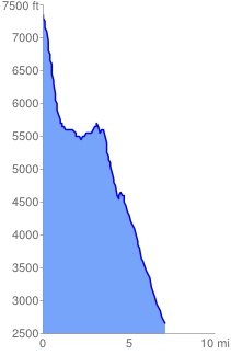
 7.275099 mi
 920.21 ft
 5621.59 ft
 -4701.37 ft
 14.63 %
GPX Downloads: Track Route
Trailheads:
 Lipan Point
![]()
| at: |
Grand Canyon |
show on map
animate
7.275099 mi
920.21 ft
5621.59 ft
-4701.37 ft
14.63 %
Lipan Point