| at: |
Ethel Stratton Vance Natural Area |
Data from David Muse
 show on map
 animate
Trail users:


Elevation Profile
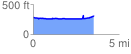
 3.587122 mi
 151.34 ft
 128.92 ft
 22.42 ft
 0.80 %
GPX Downloads: Track Route
Trailheads:
 Ethel Stratton Vance Natural Area Trailhead