| at: |
Mistletoe State Park |
Data from Positive Flow
 show on map
 animate
Trail users:


Elevation Profile
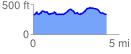
 4.316850 mi
 484.07 ft
 475.96 ft
 8.10 ft
 2.12 %
GPX Downloads: Track Route
![]()
| at: |
Mistletoe State Park |
show on map
animate
4.316850 mi
484.07 ft
475.96 ft
8.10 ft
2.12 %