| at: |
Mistletoe State Park |
Data from Positive Flow
 show on map
 animate
Trail users:


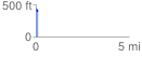
Elevation Profile
 0.100524 mi
 5.69 ft
 33.91 ft
 -28.22 ft
 6.39 %
GPX Downloads: Track Route
Trailheads:
 Mistletoe State Park
![]()
| at: |
Mistletoe State Park |
show on map
animate
0.100524 mi
5.69 ft
33.91 ft
-28.22 ft
6.39 %
Mistletoe State Park