| at: |
Rich Mountain WMA - Cartecay Tract |
Data from Positive Flow
 show on map
 animate
Trail users:


Elevation Profile
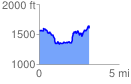
 3.214114 mi
 652.14 ft
 632.76 ft
 19.38 ft
 3.84 %
GPX Downloads: Track Route
Trailheads:
 Red-and-White, River, Boy Scout Loops