| at: |
Bear Creek/Mountaintown |
Data from David Muse
 show on map
 animate
Trail users:


Elevation Profile
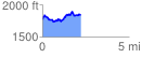
 2.218604 mi
 372.53 ft
 298.73 ft
 73.80 ft
 3.18 %
GPX Downloads: Track Route
![]()
| at: |
Bear Creek/Mountaintown |
show on map
animate
2.218604 mi
372.53 ft
298.73 ft
73.80 ft
3.18 %