| at: |
Bear Creek/Mountaintown |
Data from David Muse
 show on map
 animate
Trail users:


Elevation Profile
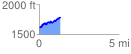
 1.337606 mi
 322.71 ft
 133.31 ft
 189.40 ft
 4.57 %
GPX Downloads: Track Route
![]()
| at: |
Bear Creek/Mountaintown |
show on map
animate
1.337606 mi
322.71 ft
133.31 ft
189.40 ft
4.57 %