| at: |
Bear Creek/Mountaintown |
Data from David Muse
 show on map
 animate
Trail users:


Elevation Profile
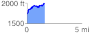
 1.615532 mi
 412.43 ft
 177.87 ft
 234.56 ft
 4.84 %
GPX Downloads: Track Route
![]()
| at: |
Bear Creek/Mountaintown |
show on map
animate
1.615532 mi
412.43 ft
177.87 ft
234.56 ft
4.84 %