| at: |
Bear Creek/Mountaintown Cashes Valley |
Data from David Muse
 show on map
 animate
Trail users:


Elevation Profile
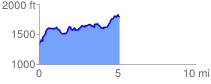
 5.154055 mi
 1009.25 ft
 550.50 ft
 458.75 ft
 3.71 %
GPX Downloads: Track Route
![]()
| at: |
Bear Creek/Mountaintown Cashes Valley |
show on map
animate
5.154055 mi
1009.25 ft
550.50 ft
458.75 ft
3.71 %