| at: |
Cashes Valley |
Data from David Muse
 show on map
 animate
Trail users:

Elevation Profile
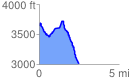
 2.498406 mi
 368.03 ft
 1005.67 ft
 -637.64 ft
 7.62 %
GPX Downloads: Track Route
![]()
| at: |
Cashes Valley |
show on map
animate
2.498406 mi
368.03 ft
1005.67 ft
-637.64 ft
7.62 %