| at: |
Grapevine Lake |
Data from David Muse
 show on map
 animate
Trail users:


Elevation Profile
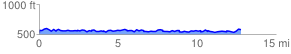
 12.976493 mi
 1497.44 ft
 1451.73 ft
 45.70 ft
 2.19 %
GPX Downloads: Track Route
Trailheads:
 MADD House LotMurrell ParkRockledge Park
![]()
| at: |
Grapevine Lake |
show on map
animate
12.976493 mi
1497.44 ft
1451.73 ft
45.70 ft
2.19 %
MADD House LotMurrell ParkRockledge Park