| at: |
Ocala National Forest |
Data from Karlos Bernart
 show on map
 animate
Trail users:


Elevation Profile
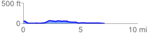
 7.191258 mi
 153.82 ft
 213.30 ft
 -59.48 ft
 0.56 %
GPX Downloads: Track Route
![]()
| at: |
Ocala National Forest |
show on map
animate
7.191258 mi
153.82 ft
213.30 ft
-59.48 ft
0.56 %