|
| at: |
Windy Gap |
Data from David Muse
 show on map
 animate
Trail users:


Elevation Profile
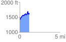
 1.169489 mi
 383.26 ft
 204.84 ft
 178.42 ft
 6.21 %
GPX Downloads: Track Route
![]()
|
| at: |
Windy Gap |
show on map
animate
1.169489 mi
383.26 ft
204.84 ft
178.42 ft
6.21 %