| at: |
Sope Creek/Cochrans Shoals |
Data from David Muse
 show on map
 animate
Trail users:

Elevation Profile
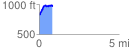
 0.835273 mi
 228.28 ft
 82.05 ft
 146.22 ft
 5.18 %
GPX Downloads: Track Route
![]()
| at: |
Sope Creek/Cochrans Shoals |
show on map
animate
0.835273 mi
228.28 ft
82.05 ft
146.22 ft
5.18 %