| at: |
Sope Creek/Cochrans Shoals |
Data from David Muse
 show on map
 animate
Trail users:

Elevation Profile
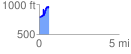
 0.612148 mi
 292.58 ft
 115.45 ft
 177.13 ft
 9.05 %
GPX Downloads: Track Route
![]()
| at: |
Sope Creek/Cochrans Shoals |
show on map
animate
0.612148 mi
292.58 ft
115.45 ft
177.13 ft
9.05 %