| at: |
Sope Creek/Cochrans Shoals |
Data from David Muse
 show on map
 animate
Trail users:

Elevation Profile
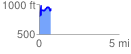
 0.738856 mi
 367.61 ft
 227.52 ft
 140.10 ft
 9.42 %
GPX Downloads: Track Route
![]()
| at: |
Sope Creek/Cochrans Shoals |
show on map
animate
0.738856 mi
367.61 ft
227.52 ft
140.10 ft
9.42 %