| at: |
Sope Creek/Cochrans Shoals |
Data from David Muse
 show on map
 animate
Trail users:

Elevation Profile
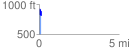
 0.148186 mi
 135.14 ft
 179.66 ft
 -44.52 ft
 22.96 %
GPX Downloads: Track Route
![]()
| at: |
Sope Creek/Cochrans Shoals |
show on map
animate
0.148186 mi
135.14 ft
179.66 ft
-44.52 ft
22.96 %