| at: |
Sope Creek/Cochrans Shoals |
Data from David Muse
 show on map
 animate
Trail users:

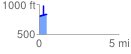
Elevation Profile
 0.475649 mi
 196.89 ft
 164.44 ft
 32.45 ft
 7.84 %
GPX Downloads: Track Route
![]()
| at: |
Sope Creek/Cochrans Shoals |
show on map
animate
0.475649 mi
196.89 ft
164.44 ft
32.45 ft
7.84 %