| at: |
North Oconee National Forest |
Data from David Muse
 show on map
 animate
Trail users:


Elevation Profile
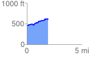
 1.936479 mi
 202.22 ft
 55.16 ft
 147.06 ft
 1.98 %
GPX Downloads: Track Route
![]()
| at: |
North Oconee National Forest |
show on map
animate
1.936479 mi
202.22 ft
55.16 ft
147.06 ft
1.98 %