| at: |
North Oconee National Forest |
Data from David Muse
 show on map
 animate
Trail users:


Elevation Profile
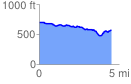
 4.554089 mi
 225.00 ft
 358.89 ft
 -133.89 ft
 1.49 %
GPX Downloads: Track Route
![]()
| at: |
North Oconee National Forest |
show on map
animate
4.554089 mi
225.00 ft
358.89 ft
-133.89 ft
1.49 %