| at: |
Flying Eagle Preserve |
Data from Karlos Bernart
 show on map
 animate
Trail users:


Elevation Profile
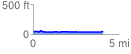
 4.111545 mi
 78.46 ft
 88.57 ft
 -10.11 ft
 0.41 %
GPX Downloads: Track Route
![]()
| at: |
Flying Eagle Preserve |
show on map
animate
4.111545 mi
78.46 ft
88.57 ft
-10.11 ft
0.41 %