| at: |
Flying Eagle Preserve |
Data from David Muse
 show on map
 animate
Trail users:


Elevation Profile
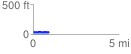
 0.930396 mi
 25.50 ft
 23.80 ft
 1.69 ft
 0.52 %
GPX Downloads: Track Route
![]()
| at: |
Flying Eagle Preserve |
show on map
animate
0.930396 mi
25.50 ft
23.80 ft
1.69 ft
0.52 %