| at: |
Flying Eagle Preserve |
Data from David Muse
 show on map
 animate
Trail users:


Elevation Profile
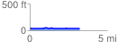
 3.242257 mi
 41.65 ft
 47.47 ft
 -5.82 ft
 0.28 %
GPX Downloads: Track Route
![]()
| at: |
Flying Eagle Preserve |
show on map
animate
3.242257 mi
41.65 ft
47.47 ft
-5.82 ft
0.28 %