| at: |
Bremen and Carrollton Area Roads |
Data from David Muse
 show on map
 animate
Trail users:


Elevation Profile
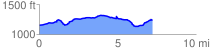
 7.313914 mi
 447.86 ft
 372.33 ft
 75.53 ft
 1.16 %
GPX Downloads: Track Route
![]()
| at: |
Bremen and Carrollton Area Roads |
show on map
animate
7.313914 mi
447.86 ft
372.33 ft
75.53 ft
1.16 %