| at: |
Iron Mountain/Sumac Creek |
Data from David Muse
 show on map
 animate
Trail users:


Elevation Profile
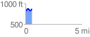
 0.575927 mi
 95.65 ft
 49.39 ft
 46.25 ft
 3.15 %
GPX Downloads: Track Route
![]()
| at: |
Iron Mountain/Sumac Creek |
show on map
animate
0.575927 mi
95.65 ft
49.39 ft
46.25 ft
3.15 %