| at: |
Iron Mountain/Sumac Creek |
Data from David Muse
 show on map
 animate
Trail users:


Elevation Profile
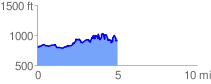
 5.052603 mi
 889.10 ft
 774.30 ft
 114.80 ft
 3.33 %
GPX Downloads: Track Route
![]()
| at: |
Iron Mountain/Sumac Creek |
show on map
animate
5.052603 mi
889.10 ft
774.30 ft
114.80 ft
3.33 %