| at: |
West Georgia Pinhoti Johns Mountain WMA |
Data from USFS GIS
 show on map
 animate
Trail users:


Elevation Profile
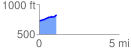
 1.090790 mi
 118.22 ft
 12.95 ft
 105.26 ft
 2.05 %
GPX Downloads: Track Route
![]()
| at: |
West Georgia Pinhoti Johns Mountain WMA |
show on map
animate
1.090790 mi
118.22 ft
12.95 ft
105.26 ft
2.05 %